Jamaica’s Hurricane Warning Downgraded

Tropical Storm Warning Now in Effect for the Island
Jamaica is no longer under a Hurricane Warning as the island is not expected to be impacted by the most dangerous winds being produced by Hurricane Matthew.
The most recent update from the National Meteorological Service can be seen below:
The Meteorological Service has downgraded the Hurricane Warning for Jamaica, replacing it with a TROPICAL STORM WARNING, as the island is now expected to be outside of the range of hurricane-force winds associated with Hurricane Matthew but likely to experience tropical storm conditions.
This means that tropical storm conditions, including possible sustained wind speeds of 63-118 km/h (39-73 mph), are expected to affect Jamaica* in 36 hours or less.
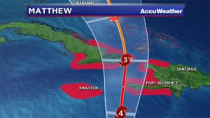
At 4:00 p.m. the centre of Hurricane Matthew was located near Latitude 16.3 degrees North, Longitude 74.7 degrees West.
This is about 305 kilometres (190 miles) southeast of Kingston, Jamaica or 360 kilometres (225 miles) southwest of Port au Prince, Haiti.
Matthew is moving toward the north near 11 km/h (7 mph) and this general motion is expected to continue through Tuesday night, with a turn toward the north-northwest forecast for Wednesday. On this track, the centre of Matthew will approach southwestern Haiti tonight and move near eastern Cuba late Tuesday.
Related Post: Brunt of Matthew Likely to Miss Jamaica, Tropical Storm Conditions Still to Be Expected
Maximum sustained winds remain near 220 km/h (140 mph), with higher gusts, and Matthew remains a Category 4 hurricane on the Saffir-Simpson Hurricane Wind Scale. Some fluctuations in intensity are possible during the next couple of days, but Matthew is expected to remain a powerful hurricane through Wednesday.
On the projected path Jamaica should be outside the range of the hurricane-force winds as Matthew moves close to southwestern Haiti tonight or early Tuesday. Hurricane-force winds extend outward up to 65 km (40 miles) from the centre and tropical storm-force winds extend outward up to 295 km (185 miles). This means that storm-force winds are likely to spread over eastern parishes, including St. Mary, Portland, St. Thomas, Kingston, St. Andrew and St. Catherine, while gusty winds reaching near tropical storm force should also be expected over central parishes.
Doppler radar confirms that light to moderate showers have already begun to affect mainly northeastern and central sections of the island; however, an extensive area of rainfall currently offshore is positioned to move over the country during this evening and tonight. Rainfall amounts of 5-10 inches are predicted over eastern parishes as Hurricane Matthew passes close to the island tonight and tomorrow.
Coastal areas of eastern parishes should also expect storm surges of 2-4 feet through Monday night. Small craft operators are reminded to remain in safe harbour until all warning messages have been lifted and wind and sea conditions return to normal.
The Meteorological Service continues to monitor the progress of this system and all interests are reminded to pay special attention to further Releases.
The next Bulletin on Hurricane Matthew will be issued at 8:00 p.m. today.
Download The Jamaican Blogs™ App for your Android device: HERE
Remember to share this article on Facebook and other Social Media Platforms. To submit your own articles or to advertise with us please send us an EMAIL at: [email protected]