Met Service Warns Jamaicans to Brace for Worst as Hurricane Beryl Intensifies and Heads West

Hurricane Beryl, the second named storm of the season, has intensified into the first hurricane and is expected to strengthen rapidly.
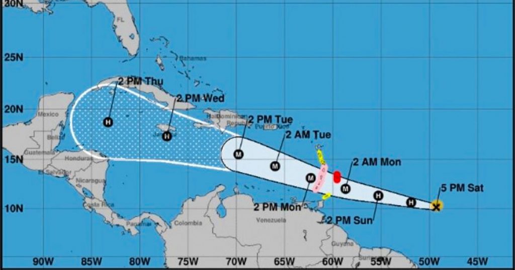
Currently classified as a Category 1 hurricane, Beryl is moving west towards the Windward Islands, with maximum sustained winds near 75 miles per hour and higher gusts.
As of 4:00 p.m., the center of Hurricane Beryl was located at latitude 10.1 North and longitude 49.3 West, moving westward at 22 miles per hour. A hurricane warning is in effect for Barbados, which is preparing for impact starting tonight.
The hurricane is expected to continue its westward to west-northwestward trajectory over the next few days. On its forecast track, Beryl’s center is projected to cross the Windward Islands late Sunday night into Monday.
Steady to rapid strengthening is forecasted, and Beryl is anticipated to become a dangerous major hurricane before reaching the Windward Islands.
Hurricane-force winds extend up to 10 miles from the center, while tropical storm-force winds extend outward up to 60 miles. The estimated minimum central pressure is 992 millibars.
While Hurricane Beryl is not an immediate threat to Jamaica, the Meteorological Service of Jamaica continues to monitor the system closely.
Projections suggest a possible direct hit on Jamaica next Wednesday, but the forecast cone indicates the center could also pass over 150 miles from the coastline.
Jamaicans are urged to prepare for the worst, with fishers advised to be ready for possible evacuation from cays and banks. Hurricane Beryl is expected to reach Category 3 status by the time it enters the Caribbean on Monday.
Remember to share this article on Facebook and other Social Media Platforms. To submit your own articles or to advertise with us please send us an EMAIL at: [email protected]


Post Comment